


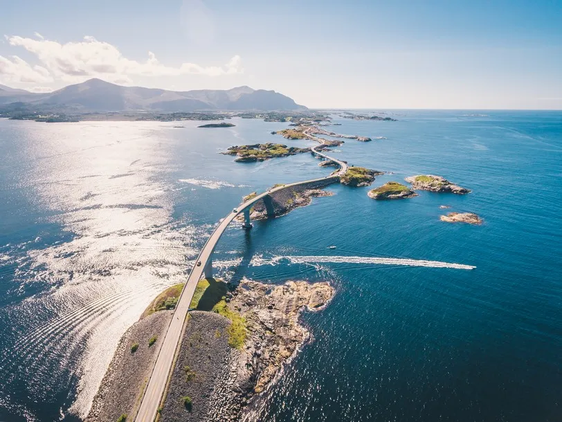
Atlanterhavsveien is Norway’s famed “road across the sea,” a camera-perfect ribbon of causeways and seven arches connecting tiny islands between Bud and Kårvåg. It’s compact—about 36 km for the full National Scenic Route, with the core bridge section around 8–9 km—making it ideal for a half-day drive or a relaxed 1–2 day coastal escape with detours. Why go: drama in any weather, easy access to viewpoints and boardwalks, minimal logistics, and year-round driveability. Crowds gather in summer weekends and during midday bus windows, but dawn, dusk, and shoulder seasons are calm and magical.
Route start
Bud fishing village (western trailhead), reachable from Molde; pick up supplies and fuel before heading northeast.
Route end
Kårvåg (eastern trailhead on Averøy), convenient for continuing to Kristiansund or looping back via inland roads.
Route stops
Bud – Farstadsanden Beach – Askevågen viewpoint – Kjeksa rest area – Eldhusøya boardwalk – Myrbærholmen fishing walk – Storseisundet Bridge – Geitøya – Vevang – Kårvåg. Optional boat hop to Håholmen island.
What you’ll see
— Storseisundet Bridge viewpoints
— Eldhusøya raised coastal boardwalk
— Myrbærholmen fishing paths and sea pools
— Farstadsanden sandy beach and dunes
— Askevågen and Kjeksa ocean lookouts
— Håholmen island (restored fishing village; boat from Geitøya)
— Bud coastal fortifications and harbor quays
— Vevang stone installations and skerry vistas
Roads
— Surface and quality: Fully paved, well maintained; short, exposed bridges with frequent crosswinds; excellent drainage and tunnels nearby.
— Route numbers: Fv64, Fv242, Fv663, Fv238, Fv235 between Bud and Kårvåg.
— Tolls: The scenic section is toll-free; city toll rings may apply in larger towns you transit.
— Speed limits: Typically 80 km/h outside settlements, 50 km/h in villages, and lower near bridges/works—obey signage.
— Enforcement: Fixed cameras and active patrols; fines are high and strictly enforced.
— Services: Fuel and workshops in Kårvåg, Averøy, Eide, Bud, and larger hubs (Kristiansund, Molde). Public toilets and parking at Eldhusøya and signed rest areas.
— Parking: Marked lots at main viewpoints; avoid stopping on bridges or shoulders.
— Seasonal: Open year-round; storms bring spray and strong gusts—check conditions, reduce speed, and keep lights on.
What to drive
— Car: Compact or midsize with good crosswind stability; AWD helpful in winter but not essential in dry conditions.
— Motorcycle: Touring or adventure bike with wind protection; be cautious on gusty bridge spans.
— Tires: Summer tires May–September; winter or studded tires October–April per local rules.
— Equipment: Mandatory warning triangle; reflective vest recommended; headlights on at all times; carry ice scraper, tow strap, and microfibre towels for sea spray. A tripod and lens cloths help for photography.
Budget
Approximate costs for 1 day (two travelers), exchange rate ~11 NOK ≈ 1 USD:
— Car rental: 900–1,400 NOK (80–130 USD)
— Fuel (100–150 km with detours): 200–300 NOK (18–27 USD)
— Food: 500–900 NOK (45–82 USD)
— Håholmen boat (optional, per person): 500–800 NOK (45–73 USD)
— Parking/viewpoints: Mostly free; allow 0–100 NOK (0–9 USD)
Total: 2,100–3,500 NOK (190–320 USD). With one overnight, add lodging below.
Accommodation
— Hustadvika Havhotell — near Farstad/Farstadsanden, sea-facing rooms and cabins
— Håholmen Havstuer — on Håholmen island (boat transfer from Geitøya), historic sea cottages
— Bryggjen i Bud Rooms — by the harbor in Bud, simple rooms above a renowned seafood spot
— Thon Hotel Kristiansund — convenient for extending to Averøy and Kårvåg
— Scandic Seilet Molde — landmark hotel on the fjord if you base near Bud/Molde
Food and drink
— Bryggjen i Bud — classic seafood plates and fish soup, harbor-side in Bud
— Eldhusøya café — light meals, coffee, and panoramic deck by the boardwalk
— Smia Fiskerestaurant — Kristiansund favorite for bacalao and local catch
— Glass Restaurant & Bar — Molde waterfront spot for modern Norwegian dishes
— Kårvåg local eateries and bakeries — simple, fresh fare for a quick stop
Safety
Police are professional; crime rates are low and bribes are nonexistent. Speed cameras are common; fines for speeding and seatbelt or phone violations are steep. DUI limits are very strict. Use headlights at all times, keep distance on wet decks and in sea spray, and never stop or walk on bridges. Emergency numbers: 112 (police), 113 (ambulance), 110 (fire).
Best time to go
May–September for long days, milder winds, and green headlands. October–April offers dramatic storms and snow-dusted horizons; it’s beautiful but colder, windier, and requires winter gear and flexible timing.
Tips and cautions
— Do not climb barriers, fish from bridges, or approach wave-washed rocks—rogue waves occur.
— Watch for sudden crosswinds on bridge crests; keep both hands on the wheel.
— Arrive early or late for emptier viewpoints and softer light.
— Drones: observe local regulations and nesting seasons; strong winds make flying risky.
— Fuel before rural stretches in the evening; some stations close early.
— In winter, check road advisories and avoid tight itineraries.
- Bars Around the World Where Celebrities Left Their Mark
- Normandy
- Sri-Lanka
- Kenya Nchi Yangu Song
- Borneo
- 9 Reasons Why People Love to Travel to Other Countries
- Sahalin
- Wrangel Island
- Kyrgyzstan
- The September 11 Terrorist Attack: How the Tragedy Changed Tourism
- Scythians
- Mammoths and travel: where to see habitats, traces and digs, and museums
- How a traveler can earn on the road
- Panama
- About
- Deadly Slopes: Ski Resorts with the Highest Fatality Rates
- Uluṟu-Kata Tjuṯa and Kakadu National Parks Etched in Time
- Macau
- Pilaf around the world: from ancient traditions to tourist routes
- Somalia: A Country of Risk and Contrasts — Is It Worth Going?