Home Twitter Telegram
First time here ?     Subscribe
  • Places
    • List
    • List (map left)
    • by Country
    • Table
    • Map
    • Simple view
    • Cameras
  • Services
    • List
    • Map
  • Tours
    • List
    • Map
    • Table
  • Site
    • About
    • Contacts
    • FAQ
    • For Place owners
    • Prices
    • Subscribe
  • Account
    • Login
    • Join (register)
    • Payment
    • Prices
    • Requests
  • Add
    • Add Place
    • Add Tour
    • Add Infrastructure
    • Add Content
    • Add Blog
    • Add Comment
    • Add Event
    • Add Rating
    • Add Request
  • Site Map
  • Partners
  • Support

Places Tours Services News Blogs Articles Events Authors Cameras Add Join

  • PLACES
    • List
    • Map
    • Table
    • List (near me)
    • Map (near me)
  • TOURS
    • List
    • Map
    • Table
  • SERVICES
  • Web Cameras
  • More
    • Blogs
    • News
    • Articles
    • Events
    • Authors
    • Telegram Channel
    • Telegram Chat
  • Site
    • Join compare
    • Plans & Prices
    • Contacts
    • FAQ
  • Add
    • Add Place
    • Add Content
    • Add Event or Date
  • Login
Add Tour
Add Sleep Place
Add Eat Place

Requests are available only for Business users !
Join as Business


Country:

Turkmenistan

Value:

Regional value

Duration:

1 h

Cost:

free

GPS:

41.056625, 52.912913
Go
Map
3.00
Kara-Bogaz-Gol Lake
Kara-Bogaz-Gol Lake
Lake
Lake

Country:

Turkmenistan

Region:

Turkmenistan

Other names:

Гарабогазкёль, Кара-Богаз-Гол

Value:

Regional value

Visit duration:

1 h

Price (adult):

free


Description:

En Ру

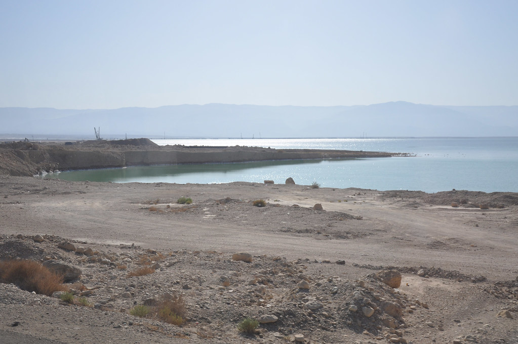
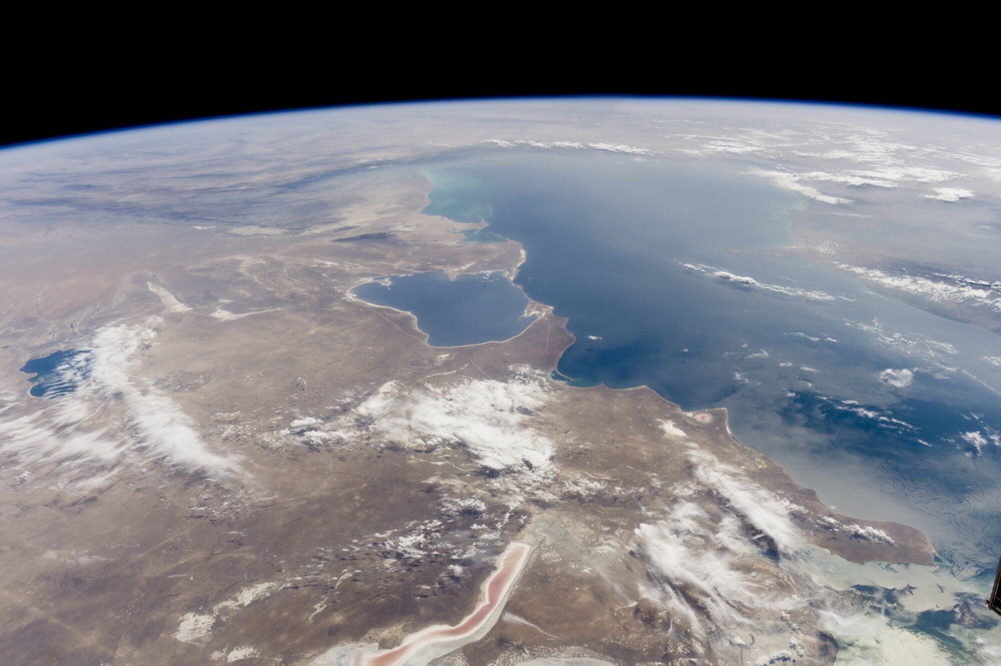
Garabogazkol or Kara-Bogaz-Gol is one of the saltiest bodies of water on Earth and a very interesting natural phenomenon with great tourist potential. It is a shallow lagoon or bay with an area of ​​about 18,000 sq. km, located in the northwest of Turkmenistan in the eastern part of the Caspian Sea.

Turk. “kara” – black, “bogaz” – throat, bay, “gol” – lake. It communicates with the sea through a narrow strait of the same name, up to 9 km long, up to 800 m wide and 3-4 m deep. In the strait, there is a constant current from the sea at a speed of 50-100 cm / s. Since 1954, underground brines (density 1.19–1.27 kg/m3, sulfate salt content 5–8%) have been extracted from a salt horizon with a thickness of 10–18 m. As a result of subsequent processing of brines, sodium sulfate, bischofite, as well as epsomite, sea salt, and medical Glauber’s salt are obtained.

Area: 18666,801 sq. km., volume: 1885347 cubic meters, depth avg: 101 m, shore length: 961,87 m, res time: -1, elevation: -30

Гарабогазкёль или Кара-Богаз-Гол — один из самых соленых водоемов на Земле и очень интересное природное явление с большим туристическим потенциалом. Это мелководная лагуна или залив площадью около 18 000 кв.км., расположенный на северо-западе Туркменистана в восточной части Каспийского моря.

Тюрк. «кара» – чёрный, «богаз» – горло, залив, «гол» – озеро. Сообщаяется с морем через одноимённый узкий пролив длиной до 9 км, шириной до 800 м и глубиной 3–4 м. В проливе наблюдается постоянное течение из моря со скоростью 50–100 см/с. С 1954 добываются подземные рассолы (плотность 1,19–1,27 кг/м3, содержание сульфатных солей 5–8%) из горизонта соли мощностью 10–18 м. В результате последующей переработки рассолов получают сульфат натрия, бишофит, а также эпсомит, морскую соль, медицинскую глауберову соль.


Categories:

Lake
Lake

Tags:

Lake

Why visit:

Boating
Fishing
Swimming
Views

Interesting:


Fitness level:


Best visit time:

January
February
March
April
May
June
July
August
September
October
November
December

Access:

Bike
Car
Car 4x4
Foot
Motorbike

Roads:

Gravel

Open:

Always

Info:


Clothing:

Seasonally


Connection:

No connection


Map and directions
By car By public transit Walking Bicycling

Add comment Cancel reply

Your email address will not be published. Required fields are marked

Author:
db3@toptourplace.com
Created:
07.08.2023
Updated:
25.03.2025
ID:
84528