Home Twitter Telegram
First time here ?     Subscribe
  • Places
    • List
    • List (map left)
    • by Country
    • Table
    • Map
    • Simple view
    • Cameras
  • Services
    • List
    • Map
  • Tours
    • List
    • Map
    • Table
  • Site
    • About
    • Contacts
    • FAQ
    • For Place owners
    • Prices
    • Subscribe
  • Account
    • Login
    • Join (register)
    • Payment
    • Prices
    • Requests
  • Add
    • Add Place
    • Add Tour
    • Add Infrastructure
    • Add Content
    • Add Blog
    • Add Comment
    • Add Event
    • Add Rating
    • Add Request
  • Site Map
  • Partners
  • Support

Places Tours Services News Blogs Articles Events Authors Cameras Add Join

  • PLACES
    • List
    • Map
    • Table
    • List (near me)
    • Map (near me)
  • TOURS
    • List
    • Map
    • Table
  • SERVICES
  • Web Cameras
  • More
    • Blogs
    • News
    • Articles
    • Events
    • Authors
    • Telegram Channel
    • Telegram Chat
  • Site
    • Join compare
    • Plans & Prices
    • Contacts
    • FAQ
  • Add
    • Add Place
    • Add Content
    • Add Event or Date
  • Login
Add Tour
Add Sleep Place
Add Eat Place

Requests are available only for Business users !
Join as Business


Country:

Netherlands

Value:

Regional value

Duration:

30 min

Cost:

free

GPS:

12.10605, -68.935273
Go
Map
1.00
Queen Emma Pontoon Bridge
Bridge
Bridge

Country:

Netherlands

Region:

Netherlands

Value:

Regional value

Visit duration:

30 min

Price (adult):

free


Description:

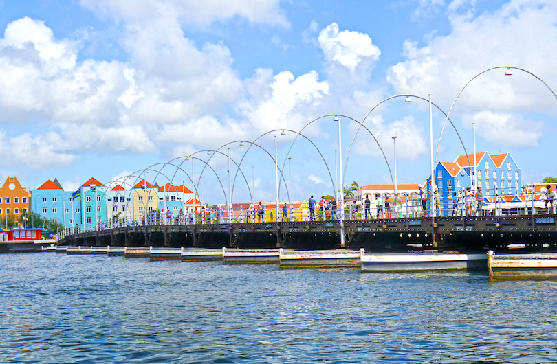
Connecting the two historic halves of Willemstad is the ever-popular Queen Emma Pontoon Bridge which spans St Anna Bay. A delight to amble across, it offers lovely views of all the brightly painted mansions and Dutch-style houses that line the water’s edge. Often referred to as the ‘Swinging Old Lady’, it was built back in 1888 to join Otrobanda in the west to Punda and Pietermaai in the east. Now lined by lit up arches at night, the floating bridge regularly opens to allow oceangoing vessels in and out of the bay. In total, it stretches over 500 feet in length with historical markers at each end explaining a bit more about the much-loved landmark.


Categories:

Bridge
Bridge

Why visit:

Check in

Interesting:


Fitness level:


Best visit time:

January
February
March
April
May
June
July
August
September
October
November
December

Access:

Bike
Car
Car 4x4
Foot
Motorbike

Roads:

Asphalt

Emergency:

112


Info:


Safety:

Safely


Clothing:

Seasonable


Connection:

Ok


Map and directions
By car By public transit Walking Bicycling

Add comment Cancel reply

Your email address will not be published. Required fields are marked

Author:
TopTourPlace.com
Created:
05.02.2024
Updated:
23.05.2024
ID:
151641