Home Twitter Telegram
First time here ?     Subscribe
  • Places
    • List
    • List (map left)
    • by Country
    • Table
    • Map
    • Simple view
    • Cameras
  • Services
    • List
    • Map
  • Tours
    • List
    • Map
    • Table
  • Site
    • About
    • Contacts
    • FAQ
    • For Place owners
    • Prices
    • Subscribe
  • Account
    • Login
    • Join (register)
    • Payment
    • Prices
    • Requests
  • Add
    • Add Place
    • Add Tour
    • Add Infrastructure
    • Add Content
    • Add Blog
    • Add Comment
    • Add Event
    • Add Rating
    • Add Request
  • Site Map
  • Partners
  • Support

Places Tours Services News Blogs Articles Events Authors Cameras Add Join

  • PLACES
    • List
    • Map
    • Table
    • List (near me)
    • Map (near me)
  • TOURS
    • List
    • Map
    • Table
  • SERVICES
  • Web Cameras
  • More
    • Blogs
    • News
    • Articles
    • Events
    • Authors
    • Telegram Channel
    • Telegram Chat
  • Site
    • Join compare
    • Plans & Prices
    • Contacts
    • FAQ
  • Add
    • Add Place
    • Add Content
    • Add Event or Date
  • Login
Add Tour
Add Sleep Place
Add Eat Place

Requests are available only for Business users !
Join as Business


Country:

Mexico

Value:

World value

Duration:

1 h

GPS:

17.989961, -97.187153
Go
Map
UNESCO
4.00
Tehuacan-Cuicatlan Valley
Originary habitat of Mesoamerica
Landscape

Country:

Mexico

Region:

Mexico

Value:

World value

Visit duration:

1 h

Description:

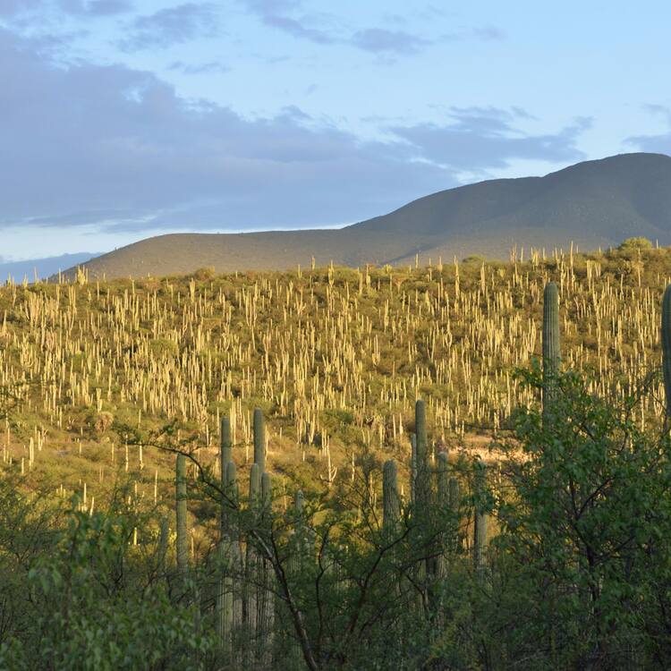
Tehuacan-Cuicatlan Valley, part of the Mesoamerican region, is the arid or semi-arid zone with the richest biodiversity in all of North America. Consisting of three components, Zapotitlan-Cuicatlan, San Juan Raya and Purron, it is one of the main centres of diversification for the cacti family, which is critically endangered worldwide. The valley harbours the densest forests of columnar cacti in the world, shaping a unique landscape that also includes agaves, yuccas and oaks. Archaeological remains demonstrate technological developments and the early domestication of crops. The valley presents an exceptional water management system of canals, wells, aqueducts and dams, the oldest in the continent, which has allowed for the emergence of agricultural settlements.


Categories:

Landscape
Landscape

Labels:

UNESCO

Why visit:

Excursion

Fitness level:


Best visit time:

January
February
March
April
May
June
July
August
September
October
November
December

Access:

Car

Roads:

Gravel

Open:

Always

Info:


Clothing:

Seasonable


Connection:

Ok


Map and directions
By car By public transit Walking Bicycling

Add comment Cancel reply

Your email address will not be published. Required fields are marked

Author:
TopTourPlace.com
Created:
13.06.2023
Updated:
25.03.2025
ID:
49379